Sobriquet 95.1: A Driftless Loop
Note: The following entry was part of a short-lived side-blog called The Ride.
I've been using Strava to track my rides for a while now, but I only upgraded to the service's premium membership a little over a month ago, largely to access the app's new personal heatmaps feature. A heatmap, Strava's website informs us, is a way to "visualize the ground you've covered" running or cycling while using their app. (Of course, with a modicum of technological knowhow, one could create his or her own heat map using free programs available online, but I opted to go with Strava's service because I was drawn to the streamlined simplicity of it). As seemingly minor a feature as the heat map generator may be, it has turned out to be one of my favorite aspects of Strava. Initially, I'd merely been curious about seeing a map of the roads I'd biked, but my attitude towards the feature has since evolved into something altogether different. Once I "saw" where I'd been on a map, with my most frequently travelled areas colored a bright red, I began to think about riding the places I hadn't yet cycled to fill in the map, even if only with the pale blue of the once-ridden route. One result of this development, predictably, was my decision to ride around Bremer, Butler, and Black Hawk counties, "collecting" roads to add to my heatmap, which introduced me to a whole slew of places I'd never previously seen, all sitting right in my proverbial backyard. A second, related development has been the growth of an urge within me to unify the routes I've ridden in and around Iowa into a single, interconnected map by cycling the areas between the various scattered routes I'd ridden previously (I say "in and around Iowa" because, as aesthetically pleasing as the resulting map would undoubtedly be, connecting my rides in New Jersey, Texas, Montana, Colorado, and Alberta doesn't seem like a reasonable short-term goal).Because I used to live in the small town of Decorah in the far northeastern part of the state, my heatmap included a blue dot indicating that, at one point long before I became a more regular cyclist, I'd once ridden my bike around town. About twenty miles north-northwest of Decorah, another blue line squiggled its way between Harmony and Peterson, two hamlets located along the Root River Trail in southeastern Minnesota, which I'd ridden a few times. Looking at my heatmap, I couldn't help but feel those two errant routes, so close yet so isolated from the rest of my Iowan rides, needed to be connected, at least to one another. I resolved to do so.
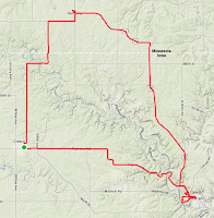
As I am wont to do, I plotted out my route from home, with the aid of Google Maps's satellite view. Although there are a number of possible paved routes between Cresco and Harmony, I was in the mood for some gravel grinding and opted to ride Yankee Avenue north out of Cresco towards the Minnesota-Iowa border. Sticking with gravel, I rode the undulating northern stretch of Yankee Avenue to 20th Street, where I headed east past St. Kierans Cemetery in Fremont and over the Upper Iowa River, before taking 333rd Avenue north to State Line Road.
As I rode up and down the hills, I enjoyed seeing the patches of forest that dotted the countryside, the sight of which contrasts with the otherwise heavily deforested Iowan landscape. While the day was sunny, I did notice a handful of rather dramatic-looking clouds bringing showers to the farms a few miles to my west. By the time I'd reached 295th Avenue in Filmore County, I realized I wouldn't be able to keep ahead of the rain. When the rain hit, it hit hard, driving into my left side and thoroughly soaking me. Fortunately, it was a comparatively brief episode and, almost before I'd had the chance to question the wisdom of riding up there on my own without any rain gear, the sun was back out and I was well on my way to drying off. From 295th, I turned east onto Route 44 and immediately noticed the huge, lane-wide paved shoulder, which, with the help of a strong tailwind, I sped along all the way to Route 139, which becomes Main Street as one heads north into Harmony.
On the ride up to Harmony, I'd toyed with the idea of taking US 52 east and south to Decorah before returning to Cresco, thereby turning my ride into a 60-plus mile loop. Invigorated by the brisk rainfall and encouraged by a favorable tailwind, I decided to go for broke and headed towards Decorah. Like Route 44, US 52 is a paved highway with a huge shoulder, presumably designed to accommodate the region's sizable horse-and-buggy-riding Amish population. Normally, I find riding along roads with posted speed limits over forty miles per hour to be nerve-wracking, but the combination of the generous shoulder width and a traffic stream limited by road resurfacing contributed to my ride towards the Iowa border feeling about as relaxing as a leisurely spin on a rail trail. Once I crossed into Iowa, however, the paved shoulder gave way to Iowa's ubiquitous crushed gravel shoulder and I had considerably less wiggle room when riding in traffic. Fortunately, the traffic was light and what few drivers did pass by were overwhelmingly considerate and gave me plenty of space.
Because I would turn south to stay on 52 in Prosper, the robust tailwind I'd enjoyed between Harmony and Canton was destined to become an occasionally vicious crosswind as I headed into Iowa, a fact I'd neglected to consider when I made my decision to lengthen my ride. I began feeling tired shortly after I crossed the border back into Iowa and the ride to Decorah took a bit longer than I had anticipated. Forty-five miles into what would become a 68 mile ride, I was well-neigh exhausted and it was only the promise of huevos rancheros at Don José's in Decorah that kept me pedaling. That and the fact that the Driftless Area is absolutely breathtaking in the full bloom of summer.
The Driftless Area, for those unfamiliar with the region, is the part of the Midwest that doesn't look anything like what most people expect the Midwest to look like. Rather than endless acres of unvarying flat farmland, the Driftless area is the loess- and colluvium-covered bluff country of Clifford D. Simak's fiction. For a cyclist accustomed to riding around areas smoothed and flattened by glaciation, the Paleozoic Plateau in which Decorah is located is both a fresh change of pace and a glute- and thigh-punishing ordeal. For a cyclist whose strongest suit is anything but climbing, the Driftless Area is, frankly, kind of intimidating.
After a nice, large dinner at Don José's, I confronted the intimidation I felt at riding back to Cresco as evening approached by telling myself in no uncertain terms that I could do it. After all, those words of encouragement seemed to be of great help to Kerry Strug as she overcame an ankle injury in the 1996 Summer Olympics, so, clearly, I reasoned, they'd help a merely fatigued Erik in so humble a task as riding a bicycle in Iowa. Thus encouraged by my inner Béla Károlyi, I pedaled up the hill on College Drive, gleefully descended towards Route 52 and began my twenty mile journey on Pole Line Road.
For the first few miles, I felt great, conquering the gradual hills and relishing the beautiful views of the forested bluffs on either side of the snaking Upper Iowa River. Then, suddenly, I came upon another hill. You can do it! I told myself, You can do it! I began my climb, willing myself up, up, and up, damn it!
Then, I stopped. I stopped to drink a bit of water and to assess the situation. You can do it, I told myself again. You most certainly can do it! And I resumed my climb up. I was determined.
I climbed on.
For, like, twenty feet. Then I stopped again. I tried to summon my Béla Károlyi. He wasn't anywhere to be found. I think he may have stayed behind at Don José's. I hear they have good margaritas.
So, there I was: alone, on a hill, tired, the sun setting, and without an enthusiastic Romanian gymnastics coach to cheer me on.
Fuck, I said, which seemed like the only thing to say upon realizing that there weren't enough gods in all the pantheons on earth whose names I could say in vain to express my feelings towards the hill. I tried everything: I stayed in my saddle, I got out of my saddle; I broke the climb into several small segments to make the task easier; I shifted down to the easiest gear I could; I drank water; I tried riding at intervals. Somehow, I made it up, covering just under a mile with an average grade of 5% in 11:36, which amounts to a scorching 4.8 miles per hour clip. Leonardo Piepoli I am not...
Call me crazy, but for some reason I really want to try that hill again.


Comments
Post a Comment